Recent Pakistan floods have affected several areas of Pakistan, below maps are showing areas severely affected by heavy rains and floods 2010,2011, 2013 and 2015 .
Below Map depicts the affected districts in flood 2011. As seen, the districts neighboring the Indus river which is the main river in Pakistan been hardest hit. The map shows that the Pak floods 2011 affected the districts of the KPK, PUNJAB but severely affected Sindh Provinces.
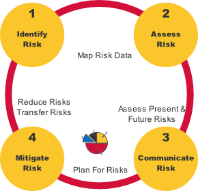
Floods in Pakistan are the most damaging of all disasters. Every year floods in Pakistan take thousands of lives,adversely affect millions of lives, leave millions of people homeless and cause properties, infrastructures and financial losses worth billions of dollars. Flood management, planning, flood inundation maps and flood hazard mapping using GIS play a key role in assessment and mitigation of the potential flood hazards.
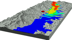
The below map is showing how manay areas affected by Pakistan flood 2010 and showing also 2010 Pakistan floods affected total areas with provinces, districts name and Indus River . The Indus River has been responsible for all major floods in Pakistan including the floods of 2010, 2011, 2014. In Pakistan there are more than 60 rivers but Indus River is the largest of all. Indus River flows from north to south and collects water from all small and large rivers and finally drops into the Arabian Sea, Karachi, Pakistan. The disastrousfloodof2010along theIndus Riverbegan in July with heavy monsoon rainfall and rapidly affected approximatelyone-fifthofPakistan'stotal landarea.
A fifth of the country’s land was flooded in 2010 floods 20 million people affected with more than 6 million homeless 43 billion USD material losses 2,000 People were reported dead and 2024 injured 895,259 homes were destroyed 1.9 million houses were damaged
Source: National Disaster Management Authority ( NDMA)
PAKISTAN FLOODS TOLL IN 2010 The 2010 floods were the country's worst in recorded history.


 Download Shapefile
Download Shapefile
Download Shapefile
Download Shapefile
Download Shapefile
Download Shapefile
Download Shapefile